Eδαφικές μετατοπίσεις στην περιοχή της Σαντορίνης με επεξεργασία δορυφορικών εικόνων Sentinel-1

Surface displacements in Santorini Island, using Sentinel-1 images


Η Επιχειρησιακή Μονάδα BEYOND του ΙΑΑΔΕΤ/ΕΑΑ, παρακολουθεί τις εδαφικές μετατοπίσεις στην περιοχή της Σαντορίνης με επεξεργασία δορυφορικών εικόνων Sentinel-1 και χρήση αυτόματης αλυσίδας επεξεργασίας που έχει αναπτυχθεί και λειτουργεί στο BEYOND. Ειδικότερα παρατηρούνται κατακόρυφες μετατοπίσεις έως 40mm/y  στη Νέα Καμένη από τον Ιούνιο του 2024 έως τον Φεβρουάριο του 2025.  Το Κέντρο Ερευνών BEYOND θα συνεχίσει να παρακολουθεί τις εδαφικές μετατοπίσεις στην Σαντορίνη και τα γύρω νησιά.


The Operational Unit BEYOND of ISAARS/NOA, monitors surface displacements in Santorini Island, using Sentinel-1 images. Line Of Sight displacements were estimated by applying the PSI technique on Sentinel-1 images, using the automated processing chain of BEYOND. Also vertical and horizontal displacements were estimated. Vertical displacements with a maximum rate of 40mm/y are identified in Nea Kameni from June 2024 to February 2025. BEYOND will continue monitoring surface displacements in Santorini and the surrounding islands.


Εικόνα 1. Κατακόρυφες μετατοπίσεις στην Σαντορίνη για την χρονική περίοδο Ιούνιος 2024- Φεβρουάριος 2025. Ανάλυση της τάσης κατακόρυφης μετατόπισης σκεδαστή στην Νέα Καμένη.

Figure 1. Vertical displacements in Santorini from June 2024 to February 2025. Trend analysis of vertical displacements of scatterer in Nea Kameni.


Διαβάστε το report / Read the report


Untitled design 3


 mysafetyplan


Το Υπουργείο Ψηφιακής Διακυβέρνησης ανακοινώνει τη λειτουργία της νέας ψηφιακής πλατφόρμας mysafetyplan.gov.gr, η οποία αποτελεί ένα εργαλείο ενημέρωσης και καθοδήγησης των πολιτών σε περιπτώσεις σεισμού και άλλων φυσικών καταστροφών και υλοποιήθηκε σε συνεργασία με το Εθνικό Αστεροσκοπείο Αθηνών. Μέσω αυτής της πρωτοβουλίας, οι πολίτες μπορούν να εντοπίσουν ασφαλείς χώρους προσωρινής συγκέντρωσης (καταφύγια) σε όλη την Ελλάδα, συμπεριλαμβανομένων των νησιωτικών περιοχών.

Διαβάστε εδώ το Δελτίο Τύπου του Υπουργείου Ψηφιακής Διακυβέρνησης 


 Minimalist Summer Photo Collage Instagram Post

Strengthening Collaboration for Public Health and Humanitarian Aid: Key Earth Observation Solutions discussed during Gaston Berger University meeting, in Senegal, 13 January 2025

Alexia Tsouni, Research Associate of the Operational Unit “BEYOND Centre of Earth Observation Research & Satellite Remote Sensing” of the Institute of Astronomy and Astrophysics, Space Applications and Remote Sensing (IAASARS) at the National Observatory of Athens (NOA) and Lamine Ndiaye, Community Facilitator of Humanitarian OpenStreetMap Team (HOT) Senegal, met with Professor Adrien Coly, Professor Dah Dieng, and other stakeholders at the Department of Geography, Faculty of Arts and Human Sciences, Gaston Berger University, Senegal on January 13th 2025, and discussed the current challenges in the region as well as the available EO-based solutions.

Alexia Tsouni presented the Early Warning System for Mosquito Borne Diseases – EYWA, Winner of the 1st EIC Horizon Prize on Early Warning for Epidemics, a prototype system addressing critical public health needs in Europe, sub-Saharan Africa, and beyond. EYWA lies under the umbrella of the EuroGEO Disaster Resilience and Health Action Group, which is led by BEYOND/IAASARS/NOA.

Lamine Ndiaye presented the services developed by OpenStreetMap Senegal (https://openstreetmapsenegal.org/), promoting access to quality healthcare for women and children in hard-to-reach parts of Senegal that also experience limited health services (https://openstreetmapsenegal.org/realisations/). HOT is an international team dedicated to humanitarian action and community development through open mapping, working together with local communities and indigenous people in Africa, Asia Pacific and Latin America (https://www.hotosm.org/).

BEYOND/IAASARS/NOA and HOT have established cooperation in the framework of the GEO-CRADLE GEO Initiative, which coordinates a sustainable GEO capacity building action and support of feasibility studies for demonstrating the value of EO, leveraging the GEO and EuroGEO innovation in Africa, Asia Pacific, Middle East, Balkans and the Black Sea.


photo 3


unnamed

The Operational Unit BEYOND Center for Earth Observation Research and Satellite Remote Sensing at the National Observatory of Athens is seeking to hire a Research associate specialized in Remote Sensing.  


taiwan

Δορυφορική συμβολομετρική απεικόνιση του πεδίου εδαφικής παραμόρφωσης από τον σεισμό στην Ταϊβάν (Μ6, 20-01-2025, 16:17:26 UTC).

Εδαφική παραμόρφωση από τον σεισμό Μ6, στην Ταϊβάν στις 20 Ιανουαρίου 2025, 16:17:26 UTC, καταγράφηκε από την υπηρεσία geObservatory της Επιχειρησιακής Mονάδας «Κέντρο Επιστημών Παρατήρησης της Γης και Δορυφορικής Τηλεπισκόπησης BEYOND» του ΙΑΑΔΕΤ/ΕΑΑ.

Συμβολογράφημα ανοδικής τροχιάς του δορυφόρου Sentinel-1, δημιουργήθηκε με επεξεργασία δορυφορικών εικόνων από τις 9 Ιανουαρίου 2025 και 21 Ιανουαρίου 2025. Στο συμβολογράφημα κάθε κροσσός συμβολής αντιστοιχεί σε εδαφική παραμόρφωση ίση με 2.8 εκ.

Όλα τα διαφορικά συμβολογράμματα που σχετίζονται με τον σεισμό, είναι διαθέσιμα στην ιστοσελίδα του geΟbsevatory (http://geobservatory.beyond-eocenter.eu/).

Εικόνα 1: Συμβολογράφημα ανοδικής τροχιάς δορυφόρου, για τον σεισμό στην Ταϊβάν (Μ6, 20-01-2025, 16:17:26 UTC).


-//-


First co-seismic interferogram of Taiwan earthquake (Μ6, 20-01-2025, 16:17:26 UTC).

Co-seismic deformation from Μ6 Taiwan earthquake in January 20, 2025, 16:17:26 UTC, was mapped by the geObservatory service of the Operational Unit BEYOND Center of Earth Observation Research and Satellite Remote Sensing of the National Observatory of Athens.

Co-seismic interferograms of ascending satellite pass no.69 of Sentinel-1 sensor, was produced.

Images of January 9, 2025 and January 21, 2025 were processed. In the produced interferogram, each fringe corresponds to a ground deformation equal to 2.8 cm.

All co-seismic and pre-seismic interferograms, associated with the event are freely available in the geObsevatory website (http://geobservatory.beyond-eocenter.eu/).

Figure 1: Co-seismic interferogram of ascending track for Taiwan earthquake (Μ6, 20-01-2025, 16:17:26 UTC)


taiwan

unnamed

The Operational Unit BEYOND Center for Earth Observation Research and Satellite Remote Sensing at the National Observatory of Athens is seeking to hire an Executive Assistant. 

 EMS GENERIC PHOTO FOR COMMS


 Copernicus Emergency Management Service (CEMS) Activations: Retrospective flood temporal analysis in Saarland, Germany (EMSN205)

 We would like to announce that the successful collaboration of our team comprising of NOA/BEYOND, National Technical University of Athens, and IDCOM, under the supervision of JRC Copernicus EMS Risk and Recovery Mapping (RRM), has resulted in valuable scientific insights to support temporal analysis of occurred flood event of mid-May 2024 that affected Saarland Region, in Germany, providing advanced mapping outputs.

Leveraging advanced 2D hydraulic modeling, along with remote sensing and GIS analysis, we've accurately captured the hydraulic behaviour of the analysed rivers and streams, providing local authorities with reliable evidence to track the floodwaters’ progression and persistence, ensuring a coordinated and efficient recovery effort.


germany


What happened?

In connection with the low-pressure system "Katinka", in parts of Rhineland-Palatinate and Saarland (Germany), persistent and heavy precipitation occurred in the period from 16 to 19 May 2024, particularly in the rivers Blies and Saar. On 17 May 2024 a flood event was reported affecting Saarland region in Germany, with the Saarland state capital Saarbrücken and several districts in Saarland declaring state of emergency due to the widespread damages. At the request of the Federal Office of Civil Protection and Disaster Assistance (BBK) of Germany, our consortium was activated by CEMS - Risk and Recovery Mapping (RRM) to provide critical insights about the dynamics of the event and the persistence of the water in the area. 


What was achieved?

For a simulation period of 7 days (16-22 May 2024) spanning the evolution of the historical flood event, we produced:

  • 12 Printable detail maps using advanced hydrological and hydraulic modelling techniques:
    • 4 Maps providing data on the Spatial Variability of Maximum Water Depth.
    • 4 Maps detailing the Duration of water persistence in the area, i.e. how long floodwaters persisted until the decay of the event.
    • 4 Maps assessing the Multi-Temporal Flood Evolution extent, examining the daily progression of flooding.
    • 1 Final Technical Report detailing all the work carried out by BEYOND/NOA, NTUA & IDCOM.
    • 1 Geodatabase which contains all the data produced for the project.
    • 4 On-line deliverables (Storymap, Dashboard, Webscene and Webmap) that interactively present all activation results.

    These insights provided a comprehensive understanding of flood dynamics on the mid-May 2024 event in Saarland, Germany and supported civil protection agencies.

    Read more about this huge amount of work here:

    See the relevant video here 

     ..........................................................................................................................................................................................................................


    Copernicus Emergency Management Service (CEMS) Activations: Retrospective flood temporal analysis in Saarland, Germany (EMSN205)

    Ανακοινώνουμε με ενθουσιασμό ότι η επιτυχημένη συνεργασία μεταξύ της Επιχειρησιακής Μονάδας μας BEYOND του ΙΑΑΔΕΤ/ΕΑΑ, του Εθνικού Μετσόβιου Πολυτεχνείου και της IDCOM, υπό την επίβλεψη της ομάδας  της Υπηρεσίας «Risk and Recovery Mapping (#RRM)» της Διαχείρισης Εκτάκτων Αναγκών του Copernicus (#CEMS) του Joint Research Centre (JRC), προσέφερε πολύτιμες επιστημονικές γνώσεις για την υποστήριξη της ανάλυσης επικινδυνότητας του πλημμυρικού γεγονότος, το οποίο σημειώθηκε 16 - 19 Μαΐου του 2024 και επηρέασε την περιοχή του Saarland στη Γερμανία, παρέχοντας χαρτογραφικά προϊόντα υψηλής ανάλυσης και ακρίβειας.

    Αξιοποιώντας προηγμένα δισδιάστατα (2D) υδραυλικά μοντέλα, σε συνδυασμό με δεδομένα τηλεπισκόπησης και ανάλυσης GIS, η ερευνητική μας ομάδα μελέτησε και υπολόγισε με ακρίβεια την υδραυλική απόκριση των ποταμών και των ρεμάτων της περιοχής μελέτης καθώς και τη διόδευση του πλημμυρικού κύματος, παρέχοντας στις αρμόδιες αρχές αξιόπιστα και τεκμηριωμένα επιστημονικά δεδομένα για την παρακολούθηση της χωροχρονικής εξέλιξης του πλημμυρικού φαινομένου, με στόχο τον συντονισμό και την αποτελεσματικότητα των δράσεων αποκατάστασης.

    Τι συνέβη;

    Στις 16-19 Μαΐου 2024, βαρομετρικό χαμηλό προκάλεσε επίμονες και έντονες βροχοπτώσεις στα κρατίδια Rhineland-Palatinate και Saarland της Γερμανίας. Οι ισχυρές βροχές επικεντρώθηκαν ιδιαίτερα στις περιοχές γύρω από τους ποταμούς Blies και Saar. Στις 17 Μαΐου 2024, οι ακραίες βροχοπτώσεις οδήγησαν σε πλημμύρες, πλήττοντας σοβαρά την περιοχή του Saarland. Η πρωτεύουσα του κρατιδίου, Saarbrücken, και πολλές άλλες περιοχές κήρυξαν κατάσταση έκτακτης ανάγκης λόγω των εκτεταμένων ζημιών που προκλήθηκαν. Κατόπιν αιτήματος της Ομοσπονδιακής Υπηρεσίας Πολιτικής Προστασίας και Βοήθειας για Καταστροφές (BBK) της Γερμανίας, ενεργοποιήθηκε η υπηρεσία CEMS - Risk and Recovery Mapping και η συγκεκριμένη μελέτη ανατέθηκε στην κοινοπραξία μας για την παροχή κρίσιμων πληροφοριών βοηθώντας στη διαχείριση και αποκατάσταση της κατάστασης.

    Τι επιτεύχθηκε;

    Για την περίοδο 7 ημερών (16-22 Μαΐου 2024), η οποία κάλυψε την εξέλιξη του πλημμυρικού γεγονότος, πραγματοποιήθηκε υδρολογική και υδραυλική προσομοίωση χρησιμοποιώντας προηγμένες τεχνικές και λογισμικά και παραδώσαμε:

    • 12 Εκτυπώσιμους Αναλυτικούς χάρτες:

    4 Χάρτες που παρουσιάζουν τη Χωρική Κατανομή του Μέγιστου Βάθους Νερού.
    4 Χάρτες που αναλύουν τη Διάρκεια Παραμονής του νερού στην περιοχή, δηλαδή πόσο διήρκεσε η παρουσία του νερού μέχρι την εξασθένιση του φαινομένου.
    4 Χάρτες που αξιολογούν την Χρονική Εξέλιξη του πλημμυρικού φαινομένου, εξετάζοντας την ημερήσια πρόοδό του.

    • 1 Τεχνική Έκθεση που περιγράφει αναλυτικά όλες τις εργασίες που εκτελέστηκαν από την ομάδα NOA/BEYOND, το ΕΜΠ και την IDCOM.
    • 1 Γεωβάση Δεδομένων που περιλαμβάνει όλα τα παραγόμενα δεδομένα του έργου.
    • 4 Διαδικτυακά Παραδοτέα (Storymap, Dashboard, Webscene και Webmap) που παρουσιάζουν διαδραστικά όλα τα αποτελέσματα της ενεργοποίησης.

    Οι παραπάνω πληροφορίες ενισχύουν σημαντικά την κατανόηση των χαρακτηριστικών της ραγδαιότητας και της επίδρασης του πλημμυρικού φαινομένου που συνέβη τον Μάιο του 2024 στο Saarland, της Γερμανίας και υποστηρίζουν τις αρχές πολιτικής προστασίας στις αποφάσεις τους για δράσεις που στοχεύουν στην πρόληψη, ετοιμότητα και αποκατάσταση από παρόμοια γεγονότα στο μέλλον.

    Διαβάστε περισσότερα για αυτό το τεράστιο έργο εδώ:

    Δείτε εδώ το σχετικό video 

     EMS GENERIC PHOTO FOR COMMS


     Copernicus Emergency Management Service (CEMS) Activations: Ground motion monitoring in Terceira Island, Azores


    We announce that the successful collaboration between our team-NOA/BEYOND, NTUA, and IDCOM, under the supervision of JRC Copernicus EMS Risk and Recovery Mapping (RRM), has resulted in valuable scientific insights on ground displacements monitoring in Santa Barbara volcano, on Terceira Island.

    By leveraging Sentinel-1 images and advanced InSAR techniques, following the analysis provided by the EGMS service until December 2023, a time-series analysis was performed to monitor deformation in Santa Barbara volcano over time. Following the seismic activity initiated on June 2022 and January 2024, the analysis presented surface deformation trends and patterns on Terceira Island. Finally, the geological interpretation of the observed InSAR deformation, provided critical information about the deformation trends on the island and contributed in planning of risk reduction activities.

    AZORES IMAGE

    What happened?

    Since June 2022, a seismic crisis in Terceira Island, was initiated. On January 14, 2024 an M4.5 earthquake occurred, with an approximate epicenter 1 km E of Serreta. Increasing seismic activity in the Island since 2022, lead the Institute of Volcanology of the University of the Azores (IVAR) to increase the volcanic alert level of Santa Barbara volcano on Terceira Island to level 3. Low- intensity shallow earthquakes recorded in the island. Although, no outgassing or deformation are observed, the University of the Azores, indicated that the alert level, could rise. Therefore, the objective of the current activation is to employ SAR Interferometry, to asses ground displacements in Terceira Island and provide to the SRPCBA, valuable insights on the deformation trends in the AOI, following the years after the Copernicus EGMS analysis.

    What was achieved?

    • Following, the seismic activity on the island, Sentinel-1 images from June 2022, January 2024 and June 2024, were analyzed.
    • Interferograms and displacement maps were produced, with dates before, during and after the intense seismic activity initiated on June 2022 and January 2024.
    • Vertical and horizontal displacements from May 2017 up to September 2024, using Sentinel-1 images in Terceira Island, were estimated.
    • Time-series plots of vertical and horizontal displacements, were generated and trend analysis was performed.

    What was produced?

    For the InSAR analysis on Terceira island, we produced:

    • Final Technical Report detailing all the work carried out by NOA, NTUA & IDCOM.
    • 1 Geodatabase which contains all the data produced for the project
    • 4 On-line deliverables (Storymap, Dashboard, Webscene and Webmap) that interactively present all the activation results.

    The results enriched the existing knowledge on the deformation trends in Terceira Island and contributed in the planning of risk reduction activities, including evacuation plans and the protection of sensitive areas.  


    Read more about this huge amount of work here:

    See the video here about the Ground motion monitoring in Terceira Island, Azores


    ..........................................................................................................................................................................................................................


    Copernicus Emergency Management Service (CEMS) Activations: Ground motion monitoring in Terceira Island, Azores

    Ανακοινώνουμε ότι η επιτυχημένη συνεργασία μεταξύ της Επιχειρησιακής Μονάδας BEYOND του ΙΑΑΔΕΤ/ΕΑΑ, του Εθνικού Μετσόβιου Πολυτεχνείου και της IDCOM, υπό την επίβλεψη της ομάδας  της Υπηρεσίας «Risk and Recovery Mapping (#RRM)» της Διαχείρισης Εκτάκτων Αναγκών του Copernicus (#CEMS) του Joint Research Centre (JRC), απέφερε πολύτιμες επιστημονικές γνώσεις για την παρακολούθηση των εδαφικών μετατοπίσεων στο ηφαίστειο Santa Barbara στη Νήσο Terceira .

    Χρησιμοποιώντας εικόνες Sentinel-1 και προηγμένες τεχνικές διαφορικής συμβολομετρίας ραντάρ, πραγματοποιήθηκε ανάλυση χρονοσειρών για την παρακολούθηση εδαφικών παραμορφώσεων στο ηφαίστειο Santa Barbara. Μετά τη σεισμική δραστηριότητα που ξεκίνησε τον Ιούνιο του 2022 και τον Ιανουάριο του 2024, η ανάλυση παρουσίασε τάσεις εδαφικής παραμόρφωσης στη Νήσο Terceira. Τέλος, η γεωλογική ερμηνεία της εδαφικής παραμόρφωσης που προέκυψε από την διαφορική συμβολομετρία ραντάρ, παρείχε κρίσιμες πληροφορίες για τις τάσεις παραμόρφωσης στο νησί και συνέβαλε στον σχεδιασμό δραστηριοτήτων μείωσης του κινδύνου.


    Τι συνέβη;

    Από τον Ιούνιο του 2022, ξεκίνησε μια σεισμική κρίση στη Νήσο Terceira. Στις 14 Ιανουαρίου 2024, σημειώθηκε σεισμός μεγέθους 4,5 με εκτιμώμενο επίκεντρο περίπου 1 χλμ. ανατολικά της Σερέτα. Η αυξανόμενη σεισμική δραστηριότητα στο νησί από το 2022 οδήγησε το Ινστιτούτο Ηφαιστειολογίας του Πανεπιστημίου των Αζορών να αυξήσει το επίπεδο κινδύνου, λόγω του ηφαιστείου της Santa Barbara στη Νήσο Terceira, στο επίπεδο 3. Παρόλο που δεν παρατηρήθηκαν εκλύσεις αερίων ή εδαφικές παραμορφώσεις, το Πανεπιστήμιο των Αζορών τόνισε ότι το επίπεδο συναγερμού θα μπορούσε να αυξηθεί. Επομένως, ο στόχος της τρέχουσας ενεργοποίησης είναι η χρήση της διαφορικής συμβολομετρίας ραντάρ για τον προσδιορισμό των εδαφικών μετακινήσεων στη Νήσο Terceira και η παροχή πολύτιμων πληροφοριών για τις τάσεις παραμόρφωσης στην περιοχή ενδιαφέροντος στην Υπηρεσία Πολιτικής Προστασίας των Αζορών (Πορτογαλία), μετά την διαθέσιμη ανάλυση της υπηρεσίας EGMS του Copernicus.


    Τι επιτεύχθηκε;

    • Αναλύθηκαν εικόνες Sentinel-1 από τον Ιούνιο του 2022, τον Ιανουάριο του 2024 και τον Ιούνιο του 2024.
    • Παρήχθησαν συμβολογραφήματα και χάρτες μετατοπίσεων με ημερομηνίες πριν, κατά τη διάρκεια και μετά την έντονη σεισμική δραστηριότητα που ξεκίνησε τον Ιούνιο του 2022 και τον Ιανουάριο του 2024.
    • Υπολογίστηκαν κατακόρυφες και οριζόντιες μετατοπίσεις από τον Μάιο του 2017 έως τον Σεπτέμβριο του 2024, χρησιμοποιώντας εικόνες Sentinel-1 στη Νήσο Terceira.
    • Δημιουργήθηκαν διαγράμματα χρονοσειρών για τις κατακόρυφες και οριζόντιες μετατοπίσεις και πραγματοποιήθηκε ανάλυση των τάσεων παραμόρφωσης.


    Τι παρήχθη;

    Για την ανάλυση InSAR στη Νήσο Terceira, δημιουργήθηκαν:

    • Τεχνική Έκθεση που περιγράφει όλες τις εργασίες που πραγματοποιήθηκαν από το ΕΑΑ, το ΕΜΠ και την IDCOM.
    • Μια γεωβάση δεδομένων που περιλαμβάνει όλα τα γεωχωρικά δεδομένα που παρήχθησαν για το έργο.
    • 4 online παραδοτέα (Storymap, Dashboard, Webscene και Webmap) που παρουσιάζουν διαδραστικά όλα τα αποτελέσματα της ενεργοποίησης.

    Τα αποτελέσματα εμπλούτισαν την υπάρχουσα γνώση για τις τάσεις παραμόρφωσης στη Νήσο Terceira, ενώ συνέβαλαν στον σχεδιασμό κατάλληλων δράσεων για τη μείωση του κινδύνου, συμπεριλαμβανομένων των σχεδίων εκκένωσης και της προστασίας των ευαίσθητων περιοχών.


    Διαβάστε περισσότερα για το τεράστιο έργο μας εδώ:

    Δείτε εδώ το σχετικό video 


     be open

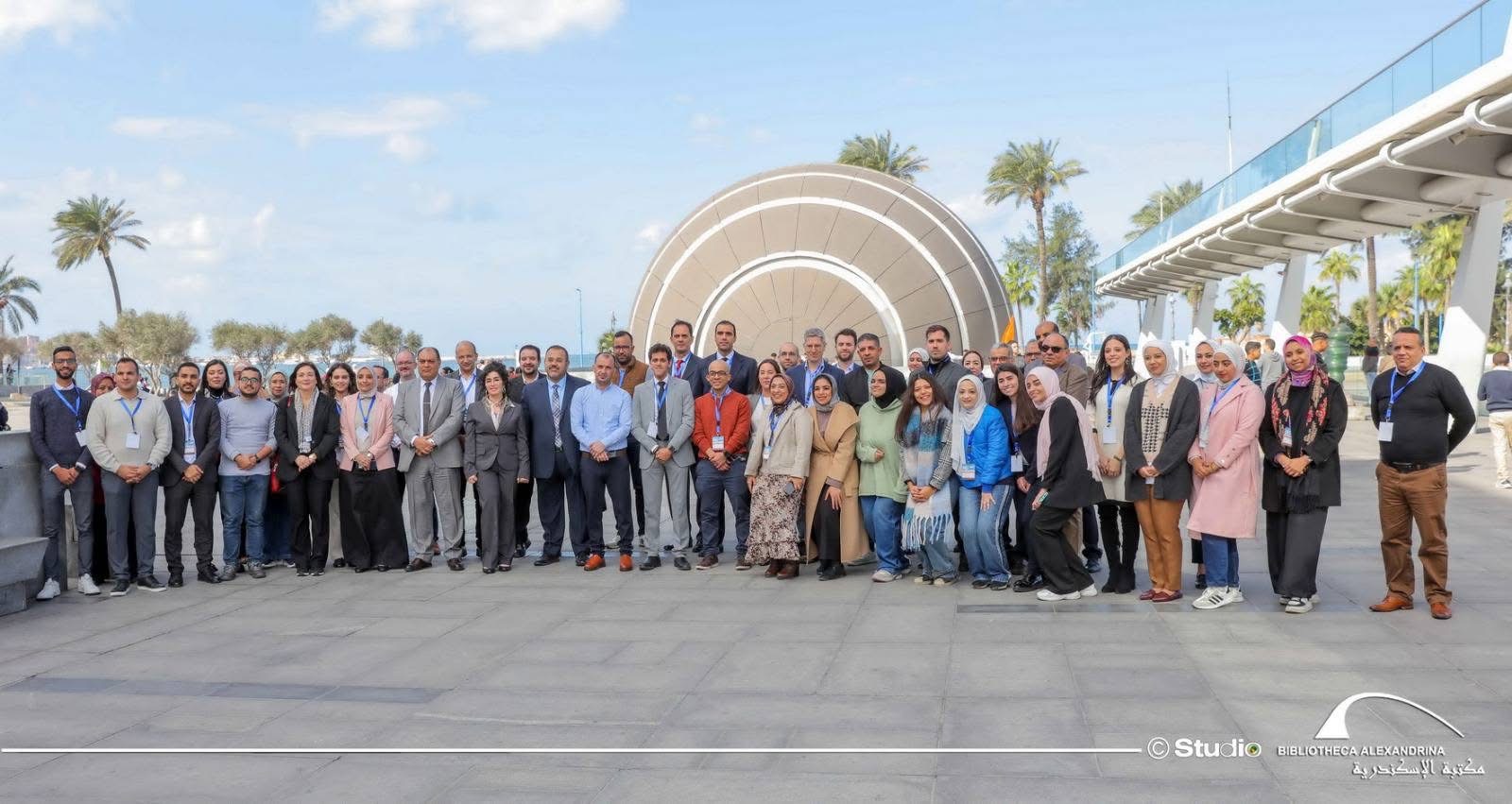
    BeOpen Kick-Off Meeting in Naples (Italy), group picture


    European consortium launches project to increase availability and usage of open datasets,
    leveraging the development of new generation of EU-wide services and AI capabilities

    Funded under the Digital Europe Program the BeOpen project is designed to increase the availability, quality and usability of public sector information in compliance with the requirement of the Open Data Directive.

    BeOpen will build on existing datasets and expertise throughout the combination of the expertise from previous CEF projects (Interstat, Odala, Spotted and Greenmove), FIWARE platform and leading SMEs/start-ups in the exploitation of data. The project will become a holistic framework that will improve technical data interoperability, semantics and quality of the public sector datasets, easing the creation and validation in real-world conditions of AI services built over existing Open Data.

    be open logo

    BeOpen, coordinated by Engineering Ingegneria Informática, brings together 18 partners from eight European countries. Eight use cases from 6 countries (Germany, Greece, Italy, Lithuania, Portugal and Spain) will test and validate the framework on the field. Berlin, 3 April 2023 - A consortium of 18 partners, composed of public bodies, large enterprises, SMEs, research institutions and non-profit organisations from eight countries (Belgium, Germany, Greece, Italy, Lithuania, Netherlands, Portugal, and Spain), met last week in Naples (Italy) to officially launch BeOpen, a project funded under the Digital Europe Programme (DIGITAL-2022-CLOUD-AI-02-OPEN-AI) and coordinated by Engineering Ingegneria Informatica, the digital transformation leader in Italy with a global footprint with around 12,000 associates and over 60 offices spread across the globe. BeOpen is born with the aim of supporting public administrations at local, regional and national level in increasing the availability, quality and usability of public sector information (High Value Datasets).

    The project outcomes will enable actors, such as SMEs, start-ups, and large companies, as well as public entities, to re-use and combine open public data across the EU for the development of information products and services, including Artificial Intelligence (AI) applications. “The project will develop a holistic framework that will improve data interoperability, semantics and the quality of public sector datasets, easing the creation and validation BeOpen has received funding from European Union's Horizon Europe Research and Innovation programme under the Grant Agreement No 101100807 1 of AI services built over existing Open Data in real-world conditions”, - commented Martino Maggio, project coordinator of BeOpen, Senior Researcher and Project Manager at Engineering Ingegneria Informatica SPA, and added: “Eight use cases in six countries will test and validate the framework over a timeframe of 18 months”.

    Strengthening Open Data management and interoperability for Smart Cities BeOpen gathers a large number of innovation experts with proven experience in data interoperability and provisioning of software for data management. Building upon the already available results coming from four Connecting Europe Facility (CEF) projects: INTERSTAT, Spotted, GreenMov, and ODALA that focus their activities on different aspects of Open Data management, BeOpen starts from a solid and tested baseline of technological solutions for the management of different kinds of data and data interoperability.

    Moreover, the project aligns with the guiding principles stated in the Living-in.EU declaration by turning EU cities and communities into smart and sustainable places where people enjoy living and working. Making data available as Open Data across the EU Member States BeOpen will support the whole Open Data process lifecycle with the aim of improving the potential of existing and new Open data datasets, maximising their value using them for the creation of IT services.

    The project will develop a customisable, cost-saving and easy to use open source ‘toolbox’ that will allow public administrations to manage High Value Datasets, make them available and be reused by any interested stakeholder. The toolbox will also facilitate the publication of those datasets in national and European Open Data Portals. Thanks to the BeOpen toolbox, SMEs, start-ups and large companies will be able to use cross-EU Open Data to scale up and offer EU-wide digital services, such as AI and ML (Machine Learning) based services. This will enable them to benefit from the EU’s digital market opportunities and growth, and ensure the sustainability of the services. BeOpen will be deployed in several municipalities and regions (Attica Region, Cartagena, Herne, Molina de Segura, Napoli, Porto, Torre Pacheco and Vilnius) through the implementation of eight use cases using existing open public sector datasets to test and validate the developed toolbox.

    The public actors involved in these use cases will benefit from the developed supporting methodologies and guidelines that accompany the deployment of the toolbox. With the help of BeOpen, all use cases are expected to improve the availability, quality, and usability of public sector information in compliance with the requirement BeOpen has received funding from European Union's Horizon Europe Research and Innovation programme under the Grant Agreement No 101100807 2 of the Open Data Directive, in force since July 2019, and the Implementing Regulation. Ultimately, the outcomes of these real-world pilots will reinforce Europe’s ability to manage urgent societal challenges, as they tackle challenges in relevant areas, such as traffic pollution, air quality, lighting and its impact on health, heatwaves, invading species or unpredictable emergencies such as fires, floods or earthquakes. Additionally, BeOpen will contribute to the common European data spaces ensuring availability of useful data and following Gaia-X principles of highest standards with regards to digital sovereignty.

    Read here the project's overview

    More about the project: https://beopen-dep.eu/about/ 


    Untitled 2048 x 1536 pxΔορυφορική συμβολομετρική απεικόνιση του πεδίου εδαφικής παραμόρφωσης από τον σεισμό στην Αιθιοπία (Μ5.7, 04-01-2025, 00:52:21 UTC).

    Εδαφική παραμόρφωση από τον σεισμό Μ5.7, στην Αιθιοπία στις 4 Ιανουαρίου 2025, 00:52:21 UTC, καταγράφηκε από την υπηρεσία geObservatory της Επιχειρησιακής μονάδας «Κέντρο Ερευνών Παρατήρησης της Γης και Δορυφορικής Τηλεπισκόπησης BEYOND» του ΙΑΑΔΕΤ/ΕΑΑ Εθνικού Αστεροσκοπείου Αθηνών. Για το συμβολογράφημα καθοδικής και ανοδικής τροχιάς του δορυφόρου Sentinel-1, χρησιμοποιήθηκαν δορυφορικές εικόνες ανοδικής τροχιάς από τις 5 Δεκεμβρίου 2024 και 10 Ιανουαρίου 2025 και καθοδικής τροχιάς από τις 29 Δεκεμβρίου 2024 και 10 Ιανουαρίου 2025. Στο συμβολογράφημα κάθε κροσσός συμβολής αντιστοιχεί σε εδαφική παραμόρφωση ίση με 2.8 εκ.

    Όλα τα διαφορικά συμβολογράμματα που σχετίζονται με τον σεισμό, είναι διαθέσιμα στην ιστοσελίδα του geΟbsevatory.

    Εικόνες 1-2: Συμβολογράφημα ανοδικής και καθοδικής τροχιάς δορυφόρου, για τον σεισμό στην Αιθιοπία (Μ5.7, 04-01-2025, 00:52:21 UTC).

    .........................................................................................................................................................................................................................

    First co-seismic interferogram of Ethiopia earthquake (Μ5.7, 04-01-2025, 00:52:21 UTC).

    Co-seismic deformation from Μ5.7 Ethiopia earthquake in January 04, 2025, 00:52:21 UTC, was mapped by the geObservatory service of the Operational Unit BEYOND Center of Earth Observation Research and Satellite Remote Sensing of the National Observatory of Athens. Co-seismic interferograms of ascending satellite pass no.87 and descending satellite pass no.79 of Sentinel-1 sensor, were produced. Images of December 5, 2024 and January 10, 2025 were processed for the ascending track and from December 29, 2024 and January 10, 2025 from the descending track. In the produced interferogram, each fringe corresponds to a ground deformation equal to 2.8 cm.

    All co-seismic and pre-seismic interferograms, associated with the event are freely available in the geObsevatory website.

    Figure 1-2: Co-seismic interferogram of ascending and descending track for Ethiopia earthquake (Μ5.7, 04-01-2025, 00:52:21 UTC)

    ethiopia 1

    ethiopia2