The BEYOND Center as a Center of Earth Observation Research & Satellite Remote Sensing has substantially contributed in NextGEOSS project. NextGEOSS, a H2020 project, aims to develop the next generation of the GEOSS Earth Observation (EO) initiative, enabling global access to EO data, prototype and higher TRL innovative services using a single platform.
The project extends the EU heritage in research and commercial use of earth observation (EO) data, encourages and stimulates the data exploitation by businesses, engages stakeholders and end-users (through the GEO-CRADLE Portal), delivers technological developments and promotes the use of GEOSS to support the creation and use of EO activities in research and commercial.
In the framework of NextGEOSS the role of NOA is critical and vastly contributes to diverse types of activities. Such as:
1) Disaster Risk Reduction Pilot - http://nextgeoss.beyond-eocenter.eu/
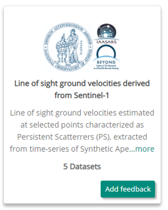
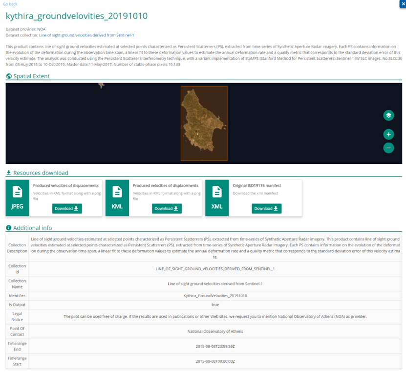
Development and integration of an EO based processing chain to NextGEOSS cloud Infrastructure that processes long time series (4-5 years) of radar data and generates ground stabilities. Ground stabilities are line of sight ground velocities estimated at selected points characterized as Persistent Scatterrers (PS), extracted from time-series of Synthetic Aperture Radar imagery (ENVISAT, Sentinel-1). Each PS contains information on the evolution of the deformation during the observation time-span, a linear fit to these deformation values to estimate the annual deformation rate and a quality metric that corresponds to the standard deviation error of this velocity estimate. The analysis was conducted using the Persistent Scatterer Interferometry technique, with a variant implementation of StaMPS (Stanford Method for Persistent Scatterers). Users are free to view and download the ground deformations (velocities), request new service for another Area of Interest and provide feedback to the provided outcomes.
Four publications has been concluded within the scope of NextGEOSS project:
- Alatza, Stavroula; Papoutsis, Ioannis; Paradissis, Demitris; Kontoes, Charalampos; Papadopoulos, Gerassimos A. 2020. “Multi-Temporal InSAR Analysis for Monitoring Ground Deformation in Amorgos Island, Greece.” Sensors 20, no. 2: 338. https://doi.org/10.3390/s20020338
- Alatza, Stavroula; Papoutsis, Ioannis; Paradissis, Demitris; Kontoes, Charalampos; Papadopoulos, Gerassimos A.; Raptakis, Costas. 2020. “InSAR Time-Series Analysis for Monitoring Ground Displacement Trends in the Western Hellenic Arc: The Kythira Island, Greece.” Geosciences 10, no. 8: 293. https://doi.org/10.3390/geosciences10080293
- Svigkas, Nikos; Loupasakis, Constantinos; Papoutsis, Ioannis; Kontoes, Charalampos H.; Alatza, Stavroula; Tzampoglou, Ploutarchos; Tolomei, Cristiano; Spachos, Thomas. 2020. “InSAR Campaign Reveals Ongoing Displacement Trends at High Impact Sites of Thessaloniki and Chalkidiki, Greece.” Remote Sens. 12, no. 15: 2396. https://doi.org/10.3390/rs12152396
- Alatza, Stavroula; Papoutsis, Ioannis; Paradissis, Demitris; Kontoes, Charalampos; Papadopoulos, Gerassimos A. 2020. “Multi-Temporal InSAR Analysis for Monitoring Ground Deformation in Amorgos Island, Greece.” Sensors 20, no. 2: 338. https://doi.org/10.3390/s20020338
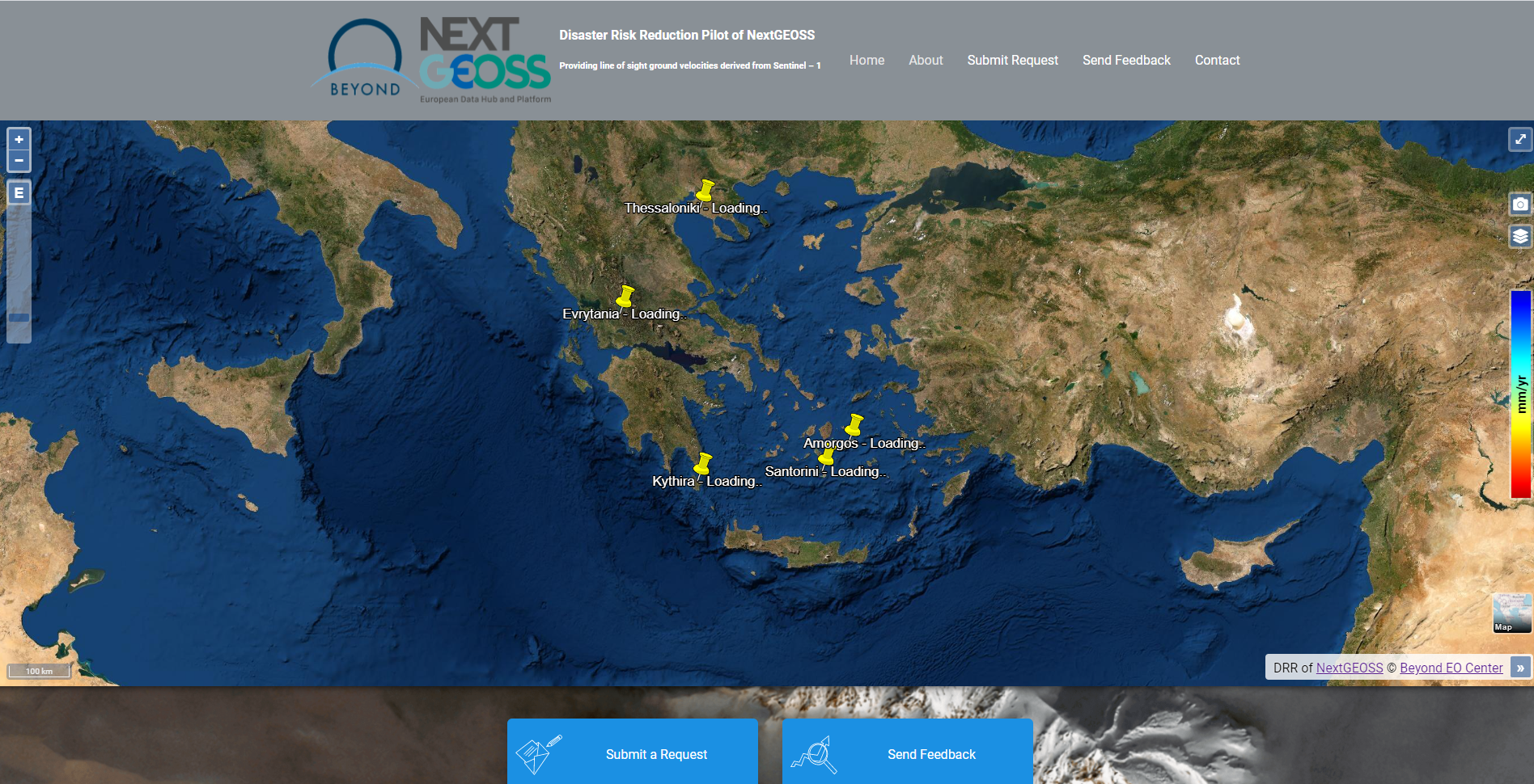
NextGEOSS’s DRR pilot website
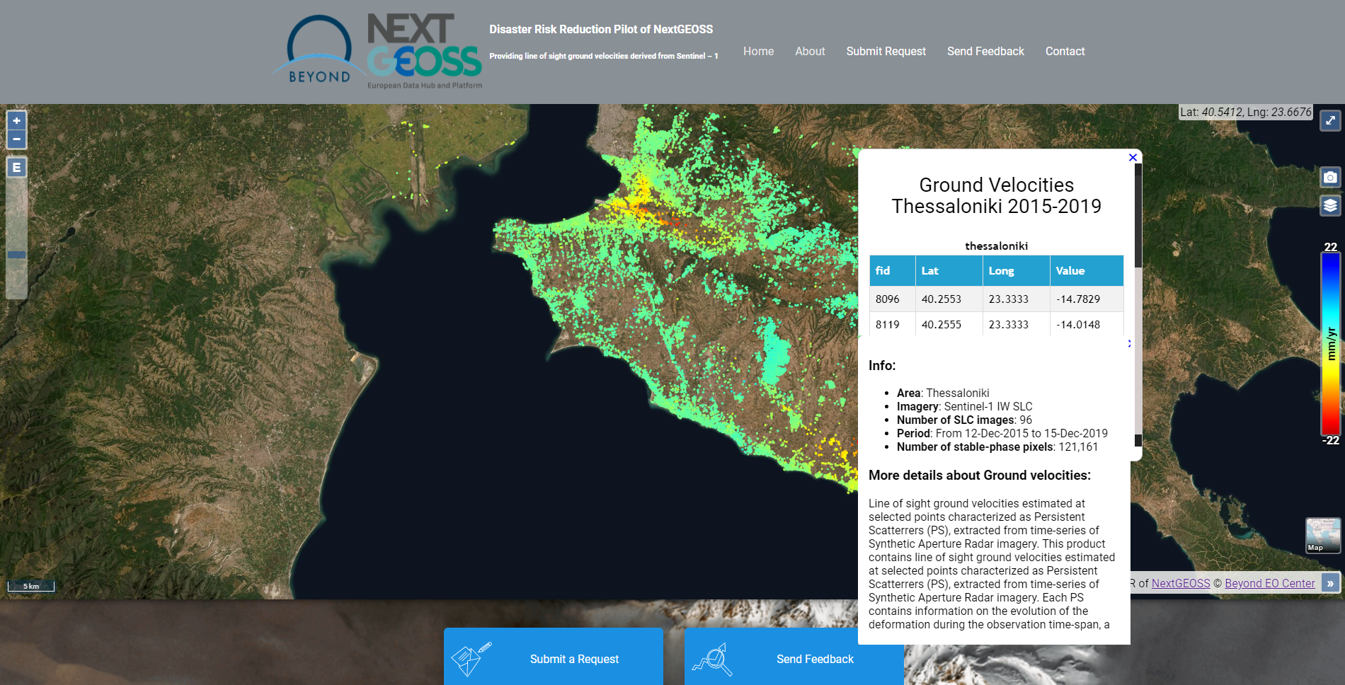
Generated ground velocities for Thessaloniki
2) Development of Data Harvesters for existing catalogues to be hosted in NextGEOSS Data Hub - https://catalogue.nextgeoss.eu/
NextGEOSS supports the GEO-DAB (GEO Discovery and Access Broker) component and in particular the OpenSearch API, enabling interconnection with heterogeneous and distributed capacities contributing to GEOSS. Therefore, NextGEOSS focuses on a fundamental change to facilitate the connectivity to the European and global data centres with new discovery and processing methods that includes the development of data connectors (Harvesters) that transform metadata into a common format adhering to OpenSearch API. Specifically NOA has developed the following harvesters:
- European Union Open Data portal (CKAN API)
- IPMA LSA SAF (Geonetwork catalogue)
- ATLANTOS-H2020 (GeoNetwork Catalogue)
- FAO (GeoNetwork)
- Energydata (CKAN API)
- geObservatory (RestAPI)
- NOA/BEYOND Ground Segment Datahub (RestAPI)
- EuroGOOS (CKAN API)
- JRC_EMIS (CKAN API)
3) Expose DRR pilot output data to NextGEOSS Catalogue
Disaster Risk Reduction (DRR) (http://nextgeoss.beyond-eocenter.eu/) has performed 5 processing campaigns in area of great interest in Greece. Each processing campaign has generated line-of-sight ground velocities based on Persistent Scatterer Interferometry technique. Within the scope of NextGEOSS a harvester has developed for retrieving metadata content for each processing campaign accompanied with a kml file and a png image.
Number of processing Campaigns
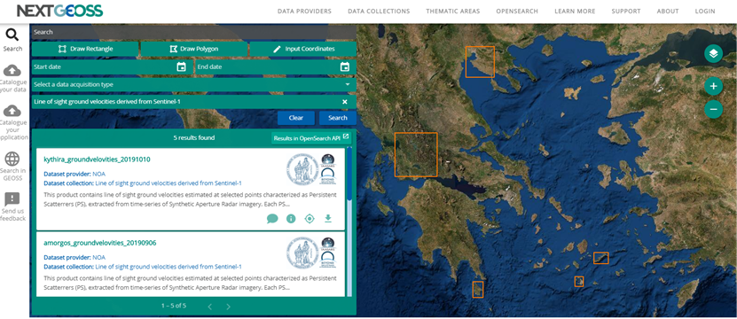
DRR pilot outputs products
3) Expose NOA’s/BEYOND’s geObservatory output data to NextGEOSS Datahub
NextGEOSS is automatically harvesting output products (co- & pre- seismic interferograms) from an end-to-end value chain that is based on Sentinel-1 imagery and has been developed within the scope of BEYOND project. The service is exploiting co-seismic and pre-seismic interferograms after major geohazard events (earthquakes, volcanic activity, landslides, etc.), thus providing to stakeholders information about the surface deformation associated with a particular event.
For more information visit: http://geobservatory.beyond-eocenter.eu/
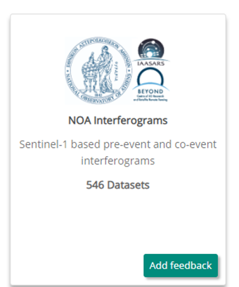
Number of interferograms
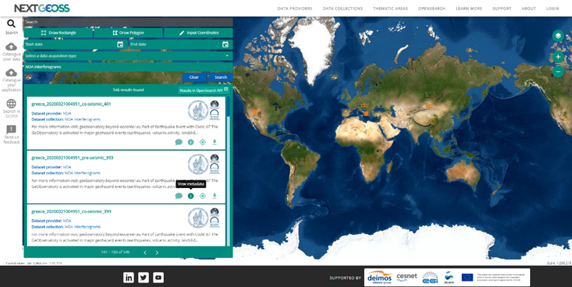
Visualization of geObservatory’s output products into NextGEOSS catalogue
4) Expose NOA’s/BEYOND’s Ground Segment satellite data to NextGEOSS Datahub
The following datasets are being exposed from NOA’s/BEYOND’s ground segment as metadata information to NextGEOSS Data Hub:
- Medium Resolution Spectral Imager (MERSI);
- Advanced Very High Resolution Radiometer (AVHRR/3);
- Visible Infrared Imaging Radiometer Suite (VIIRS);
- Moderate Resolution Imaging Spectroradiometer (MODIS);
- Atmospheric InfraRed Sounder (AIRS) products;
All the above mentioned products have been collected from the premises of the National Observatory of Athens. For specific product information please consult the following link:
https://groundsegment.space.noa.gr/products
Number of NOA’s/BEYOND’s polar orbit satellite data
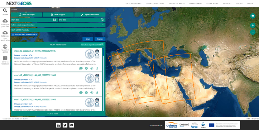
Visualization of NOA’s Ground Segment Data into NextGEOSS catalogue
5) Sentinel Broker Hub
Within the scope of NextGEOSS and relying on NOA’s vast knowledge and experience in monitoring Sentinel Hubs, NOA team has developed an Sentinel Linker Service that enables users to have access to different hubs which are using DHuS software.
Problem to Tackle:
All data hubs tend to have different data offerings. One aspect is the geographic coverage (e. g. the Hellenic Mirror Site concentrates on the Mediterranean Sea) and different data eviction policies with respect to the age of observations (old observations are evicted from the online archive). Nevertheless, some archives (such as CODE-DE) offer a reload functionality for older (and already evicted) datasets.
Moreover, all hubs experience different performances with respect to download speed, integrity, response times, availability and product latency.
Solution:
Tackling the abovementioned problem, NOA has developed an umbrella application called "Sentinel Data Linker Service" that federates Sentinel data. The developed solution has showcased the connection with 8 different Sentinel Hubs:
- SciHub: https://scihub.copernicus.eu/dhus
- ApiHub: https://scihub.copernicus.eu/apihub
- Sentinel-5P PreOps: https://s5phub.copernicus.eu/dhus
- Austria National Mirror Site: https://data.sentinel.zamg.ac.at
- Finnish National Mirror Site: https://finhub.nsdc.fmi.fi
- Hellenic National Mirror Site: https://sentinels.space.noa.gr/dhus
- Portugal National Mirror Site: https://ipsentinel.ipma.pt/dhus
- Czech Republic National Mirror Site (after contacting NextGEOSS): https://dhr1.cesnet.cz/
Main advantages
The developed application provides:
- Linkage to the federated Copernicus Sentinels Hubs
- Access to a single hub instead of looking across several Sentinel Hubs to find the appropriate products for your application
- Access to all Sentinel mission data, no geographic restrictions
- Better timeliness and reduced lead times for accessing Sentinel products ------> more important for NRT applications
- Less performance variability by exploiting Hub diversity
Access to the service: https://sentinel.broker.space.noa.gr/#/home
For more information please consult the following link: http://www.beyond-eocenter.eu/index.php/web-services/sentinel-missions-federated-access
All the above mentioned activities have been conducted under the framework of NextGEOSS project which has received funding from the EU H2020 program under grant agreement No. 730329.