Δορυφορική συμβολομετρική απεικόνιση του πεδίου εδαφικής παραμόρφωσης από τον σεισμό στην Tαϊβάν (Μ7.4, 02-04-2024, 23:58:09 UTC).
Εδαφική παραμόρφωση από τον σεισμό Μ7.4, στην Ταϊβάν στις 2 Απριλίου 2024, 23:58:09 UTC, καταγράφηκε από την υπηρεσία #geObservatory της Επιχειρησιακής μονάδας «Κέντρο Επιστημών Παρατήρησης της Γης και Δορυφορικής Τηλεπισκόπησης BEYOND» του ΙΑΑΔΕΤ/ΕΑΑ. Συμβολογράφημα καθοδικής τροχιάς του δορυφόρου Sentinel-1, δημιουργήθηκε με χρήση εικόνων από τις 29 Μαρτίου 2024 και 10 Απριλίου 2024. Στο συμβολογράφημα κάθε κροσσός συμβολής αντιστοιχεί σε εδαφική παραμόρφωση ίση με 2.8 εκ.
Όλα τα διαφορικά συμβολογράμματα που σχετίζονται με τον σεισμό, είναι διαθέσιμα στην ιστοσελίδα του geΟbsevatory http://geobservatory.beyond-eocenter.eu/
.........................................................................................................................................
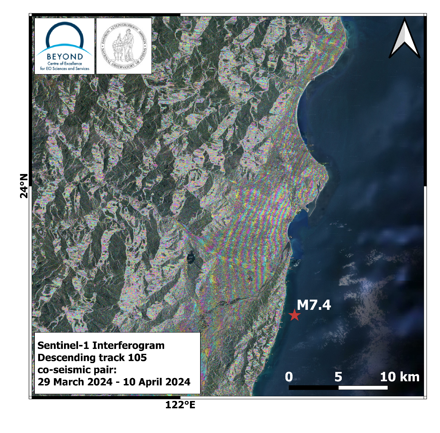
First co-seismic interferogram of Taiwan earthquake (Μ7.4, 02-04-2024, 23:58:09 UTC).
Co-seismic deformation from Μ7.4 Taiwan #earthquake in April 02, 2024, 23:58:09 UTC, was mapped by the geObservatory service of the Operational Unit BEYOND Center of Earth Observation Research and Satellite Remote Sensing of the National Observatory of Athens. Co-seismic interferogram of descending satellite pass no.105 of Sentinel-1 sensor, was produced with the use of two images of March 29, 2024 and April 10, 2024. In the produced interferogram, each fringe corresponds to a ground deformation equal to 2.8 cm.
All co-seismic and pre-seismic interferograms, associated with the event are freely available in the geObsevatory website
http://geobservatory.beyond-eocenter.eu/