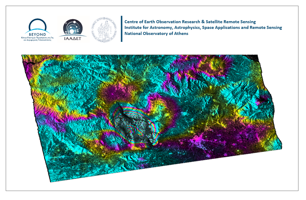
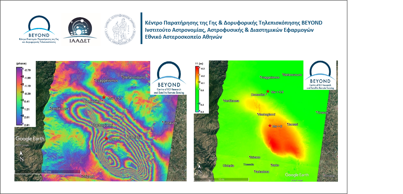
GROW Event Banner 1


Την Πέμπτη 7 Φεβρουαρίου, ώρα 18:00-21:00 στο Ωδείο Αθηνών, διοργανώνεται από το GROW Observatory ανοιχτή εκδήλωση και συζήτηση με θέμα “Πολίτες και Ανοιχτά Δεδομένα για τη Βιώσιμη Ανάπτυξη”. Τί είναι η επιστήμη των πολιτών και πώς λειτουργεί ένα παρατηρητήριο πολιτών σε τοπικό, εθνικό και ευρωπαϊκό επίπεδο; Ποιοί είναι οι 17 Στόχοι για τη Βιώσιμη Ανάπτυξη που έχουν ορίσει τα Ηνωμένα Έθνη ενόψει 2030 και πώς επηρεάζουν την αναπτυξιακή ατζέντα της χώρας μας;

Διακεκριμένοι ομιλητές από ελληνικούς και βρετανικούς φορείς έρευνας και κοινωνικής δράσης όπως το Edinburgh Futures Institute, το Πανεπιστήμιο του Dundee, το Εθνικό Αστεροσκοπείο Αθηνών, η Ελληνική Πλατφόρμα για την Ανάπτυξη και η Οργάνωση Γη παρουσιάζουν νέες στρατηγικές, εργαλεία και προγράμματα σε μία βραδιά ενημέρωσης, συζήτησης και δικτύωσης με επίκεντρο τις κοινότητες ενεργών πολιτών, τα ανοιχτά δεδομένα και τη βιώσιμη ανάπτυξη; Πώς μπορούν έξυπνα κινητά, αισθητήρες χαμηλού κόστους, ανοιχτές πλατφόρμες οπτικοποίησης δεδομένων και δορυφορικά συστήματα να παρέχουν ακριβέστερες μετρήσεις για την πρόβλεψη ακραίων καιρικών δεδομένων και άλλων, ζωτικής σημασίας για την ανθρωπότητα, προκλήσεων;

Το Κέντρο Αριστείας BEYOND συμμετέχει στην ανοιχτή συζήτηση με θέμα "The Copernicus Programme and the importance of Earth Observation"

Δείτε μας ζωντανά μέσω live streaming:

https://www.youtube.com/watch?v=w3V33FlWVkg&feature=youtu.be

Citizens and Open Data for Sustainable Development

On Thursday, February 7th from 6pm to 9pm, at the Athens Conservatoire, the GROW Observatory is organising a public event on “Citizens and Open Data for Sustainable Development”. This forum will address a number of important topics: What is Citizen Science? What are the 17 Sustainable Development Goals that the United Nations have set out to achieve by 2030? How do they affect the development agenda in Greece? How can smartphones, low-cost sensors, open data visualisation platforms and satellite systems provide more specific measurements and better predictions for critical situations such as extreme weather events like flooding and droughts?

Distinguished speakers from Greece and Britain, including the Edinburgh Futures Institute, the University of Dundee, the National Observatory of Greece, the Hellenic Platform for Development and Organization Earth present new strategies, tools and programmes during an evening of information, discussion and networking, focusing on active citizenship, open data and sustainable development.

Dr. Haris Kontoes is participating in the event with an oral presentation on “The ESA Copernicus Programme and the importance of Earth Observation”.


LIVESTREAMING

https://www.youtube.com/watch?v=w3V33FlWVkg&feature=youtu.be


20190125event


Διάλεξη με τίτλο "Το Ευρωπαϊκό Κέντρο Αριστείας BEYOND στη διαχείριση των φυσικών καταστροφών με χρήση δορυφορικής τηλεπισκόπησης".

Παρασκευή 25/01/2019, 18.00-21.00, Πανεπιστήμιο Αιγαίου, Μυτιλήνη


20190125hiring


Το Κέντρο Αριστείας BEYOND προσλαμβάνει συνεργάτη με ειδίκευση στην πληροφορική (DevOps engineer).

Δείτε την πρόσκληση ενδιαφέροντος και στείλτε μας το βιογραφικό σας.

https://national-observatory-of-athens-4.workable.com/j/2F415E4807?fbclid=IwAR2LavPF4gQz3UhOUzSgB0WjsGTQsOsEtHTOt8U17HAFo6slyK8MiY46HaM


CEN FM18 logo 1

Dr. Haris Kontoes is participating in the AGU FALL MEETING 2018 as an Invited Speaker in the session NH34C: Wildfires: Triggers, Predictability, and Impact Assessment on Wednesday 12/12/2018.

The speech is entitled  "THE FIREHUB: A PROTOTYPE OPERATIONAL EARLY WARNING, FIRE DETECTION AND BURNED AREA MAPPING SYSTEM" and more information is available at: https://agu.confex.com/agu/fm18/meetingapp.cgi/Session/62882

Abstract:

The BEYOND FireHub System consists of 1) the Real‐Time Active Fire Monitoring and 2) the Real‐
Time and Diachronic Burnt Scar Mapping services. Real‐Time Fire Monitoring service is a 24/7 active fire detection service for monitoring forest fires in near‐real time. The system ingests satellite acquisitions from every 5 minutes to a few hours from missions MSG SEVIRI, EOS/AQUA &TERRA, SUOMI NPP, and FY satellites. It incorporates fully automatic processing chains for data fusion, modeling and data classification, in the context of a co‐designed and co‐development service approach with the participation of the end‐users. The system accounts for wind, ground morphology and altitudinal data, and integrates together with the satellite observations fuel and fire proneness data in a spatial resolution of 500 m. This is 50 times better compared to the raw resolution of MSG SEVIRI sensor. The system has been validated and calibrated with real data to cover operational needs in the wider area of south‐east Mediterranean. The Diachronic Burnt Scar Mapping service is a fully automatic multi‐sensor processing chain that takes as input satellite images of any available spatial and spectral resolution and produces precise diachronic burnt area and damage assessment products over the wider Mediterranean. The service has mapped the annual burnt areas and the corresponding damages for a period spanning the last 35 years in Greece. It is based on the use of Landsat TM, SPOT XS, IKONOS, FORMOSAT, and recently Sentinel‐2& Sentinel-3 imagery. The service has been enhanced to address near real‐time Burnt Scar Mapping needs at various spatial resolutions, depending on the acquired satellite imagery. It ingests data acquired by the NOA Ground Segment and the Hellenic National Sentinel Data Mirror Site, providing near real time access to Sentinel‐2 and Sentinel-3 data. The underlying algorithm for automated Burnt Scar mapping is based on the innovative use of Level Set methods.

pdf Click here to see agenda

4

BEYOND team will participate in the Copernicus4Regions event which will take place in European Parliament on  22 and 23 of November.

The event is organising by the European Commission, the European Space Agency and the Network of European Regions Using Space Technologies (NEREUS) and user stories on
how Copernicus data help European local and regional authorities will be presented. These  Copernicus user stories will be featured as a publication targeting decision-makers as well as the general public.

BEYOND is participating in one of these user stories through RECAP H2020 project, which  is about "Reinforcing Common Agriculture Policy".

Download the Copernicus4regions Publication here.

http://www.nereus-regions.eu/wp-content/uploads/2017/10/PUBLICATION_Copernicus4regions_2018.pdf

3

Dr Haris Kontoes, Coordinator of the BEYOND team will  participate in the  SG[Greece] 2018 event which took place in Athens on Friday 23/11.

SG[Greece] 2018 will be a 1-day short informative event with talks open to the public (free admission), to be hosted on November 23, 2018 at the Ceremony Hall of the National Technical University of Athens.

The venue is located at the Administration and Management Building, 15704, Zografos, Athens, Greece (EU) {https://goo.gl/maps/J5ZKg6b1CAK2}.

SG[Greece] 2018 will be organized as part of the ESA- and SGAC-supported European Space Talks initiative. Speakers will share their experience of working in space institutes and companies in Greece or abroad, raise awareness regarding a career in the space sector and talk about scientific missions, technology applications, spin-offs, education and other capabilities.

2 images

Η ομάδα του BEYOND συμμετέχει στο εκπαιδευτικό σεμινάριο ¨Εφαρμογές GNSS και Δορυφορικών Παρατηρήσεων στην Ανάλυση της Γης" την Πέμπτη 22/11/2018, το οποίο διεξάγεται  στο πλαίσιο του ερευνητικού προγράμματος  HELPOS - Ελληνικό Σύστημα Παρατήρησης Λιθόσφαιρας.

Στο εκπαιδευτικό σεμινάριο θα παρουσιαστεί η υπηρεσία του BEYOND geObservatory: μια εφαρμογή για την έγκαιρη εκτίμηση των παραμορφώσεων του έδαφος που σχετίζονται με γεω-κινδύνους.

1 papoutsis

Dr Haris Kontoes, Coordinator of the BEYOND team participated in the ESA-Φ week event from 12-16 November 2018 in Frascati, Italy.

In parallel on Friday 16th of November the EOPEN project organised the 1st Review project meeting also in Frascati.

The BEYOPND team as a partner of the EOPEN project participated in the meeting by presenting the Food security pilot (WP2) and the progress of the WP3 (EO and  non-EO data Acquisition)

Template Landscape SithoniaFinal2

Ο χάρτης έχει δημιουργηθεί από το Κέντρο Αριστείας BEYOND του ΙΑΑΔΕΤ/ΕΑΑ.O σκοπός του προϊόντος αυτού είναι να δώσει μια νεότερη εκτίμησης της επιφάνειας των καμένων εκτάσεων της πυρκαγιάς στην ευρύτερη περιοχή της Σάρτης του Δ. Σιθωνίας που ανιχνεύθηκε στις 25/10/2018 (ώρα 05.35 π.μ.) από την υπηρεσία ανίχνευσης και παρακολούθησης πυρκαγιών FireHub του Ευρωπαϊκού Κέντρου Αριστείας Τηλεπισκόπησης για την Διαχείριση Φυσικών Καταστροφών BEYOND του ΙΑΑΔΕΤ/ΕΑΑ (www.noa.gr).

Η εκτίμηση της καμένης έκτασης ανέρχεται στα 553 ha και είναι ακριβέστερη σε σχέση με την προγενέστερη εκτίμηση (26/10/2018), δεδομένου ότι ο δορυφορικός αισθητήρας παράγει δεδομένα υψηλότερης χωρική ανάλυσης (10m) ενώ οι λήψεις χαρακτηρίζονται από μηδενικά ποσοστά νεφοκάλυψης και παρουσίας καπνού.

Η εκτίμηση αυτή έγινε εφαρμόζοντας τη Διαφορά του Κανονικοποιημένου Δείκτη Καμένων Εκτάσεων (NBR), αξιοποιώντας την πρότερη (Sentinel2B, 16-10-2018) και τη μεθύστερη του γεγονότος εικόνα (SENTINEL-2Β, 26-10-2018).

Sithonia day2 version1

Ο παρακάτω χάρτης έχει δημιουργηθεί από το Κέντρο Αριστείας BEYOND του ΙΑΑΔΕΤ/ΕΑΑ. O σκοπός του προϊόντος αυτού είναι να δώσει μια νεότερη εκτίμησης της επιφάνειας των καμένων εκτάσεων της πυρκαγιάς στην ευρύτερη περιοχή της Σάρτης του Δ. Σιθωνίας που ανιχνεύθηκε στις 25/10/2018 (ώρα 05.35 π.μ.) από την υπηρεσία ανίχνευσης και παρακολούθησης πυρκαγιών FireHub του Ευρωπαϊκού Κέντρου Αριστείας Τηλεπισκόπησης για την Διαχείριση Φυσικών Καταστροφών BEYOND του ΙΑΑΔΕΤ/ΕΑΑ (www.noa.gr).

Η εκτίμηση της καμένης έκτασης (630ha) βασίστηκε σε δορυφορικά δεδομένα μέσης ανάλυσης VIIRS συνδυάζοντας δυο διαδοχικά περάσματα από τους δορυφόρους NOAA-20 και NPP. Η εκτίμηση αυτή είναι ακριβέστερη σε σχέση με την προγενέστερη, δεδομένου ότι οι σημερινές λήψεις (26/10/2018) είναι καθαρότερες, χωρίς καπνό και νεφοκάλυψη. Η καμένη έκταση είναι υπολογίσζεται στα 630 εκτάρια.


Second updated estimation by BEYOND Center of the fire in Sithonia-Chalikidiki

The estimation of the burnt area (630ha) is based on the medium spatial resolution VIIRS satellite data, combining two subsequently passes of
NOAA-20 and NPP satellites. The current estimation is more precise than the former one since the current acquisitions (26/10/2018) are not compromised by either smoke or clouds.