iran

In July 1, 2022, 23:25:15 UTC, an M6.3 earthquake occurred in Southern Iran. Co-seismic deformation was mapped by the geObservatory service of BEYOND Center of Earth Observation Research and Satellite Remote Sensing of the National Observatory of Athens. The first co-seismic interferogram was produced with the use of two Sentinel-1 images of June 22, 2022 and July 4, 2022 of ascending satellite track 130. In the co-seismic interferogram, surface deformation induced by the seismic event is clearly presented bυ numerous fringes. 11 fringes can be detected. Each fringe corresponds to a ground deformation equal to 2.8 cm, resulting to an overall of almost 30 cm of ground deformation. All co-seismic and pre-seismic interferograms, associated with the event are freely available in the geObsevatory website (http://geobservatory.beyond-eocenter.eu/).

 china

On January 07, 2022, 17:45:31 UTC a strong earthquake of M6.2 occurred in Northern Qinghai, China. geObservatory service of BEYOND Center of Earth Observation Research and Satellite Remote Sensing of the National Observatory of Athens, was activated and detected co-seismic deformation induced by the seismic event. The first co-seismic interferogram, was generated from Sentinel-1 SLC images of descending track 33, of December 29, 2021 and January 10, 2022. Each fringe in the interferogram corresponds to ground deformation equal to 2.8 cm. All co-seismic and pre-seismic interferograms, associated with the event are freely available in the geObsevatory website (http://geobservatory.beyond-eocenter.eu/), which is updated with new interferograms as long as new Sentinel-1 satellite data becomes available at the Hellenic Mirror Site.

 HAITI

First co-seismic interferogram of Haiti region earthquake.
On August 14, 2021, 12:29:09 UTC a strong earthquake of M7.2, occurred in Haiti region. It was followed by a second seismic event of M5.9, on August 15, 2021, 03:20:45 UTC. The geObservatory service of BEYOND Center of Earth Observation Research and Satellite Remote Sensing of the National Observatory of Athens, was activated and mapped ground deformation in the affected region. Sentinel-1 SLC images of descending track 142, of August 3, 2021 and August 15, 2021, were used to produce the first co-seismic interferogram, where deformation of both seismic events is mapped. Each fringe in the interferogram corresponds to ground deformation equal to 2.8 cm. All co-seismic and pre-seismic interferograms, associated with the events are freely available in the geObsevatory website (http://geobservatory.beyond-eocenter.eu/). The website will be updated with new interferograms as long as new Sentinel-1 satellite data becomes available at the Hellenic Mirror Site.

20210521qinghai

First co-seismic interferograms, Southern Qinghai, China earthquake.

Picture1

The geObservatory service of BEYOND Center of Earth Observation Research and Satellite Remote Sensing of the National Observatory of Athens, was again activated on March 4, 2021, 18:38:17 UTC, to monitor a new strong earthquake, near Elassona city in Thessaly, with a magnitude of Mw=5.9. 

Η υπηρεσία geObservatory του Κέντρου Παρατήρησης της Γης και Δορυφορικής Τηλεπισκόπησης BEYOND του Εθνικού Αστεροσκοπείου Αθηνών, ενεργοποιήθηκε εκ νέου στις 4 Μαρτίου του 2021 στις 18:38:17 UTC, μετά τον νέο ισχυρό σεισμό, κοντά στην πόλη της Ελασσόνας, στην Θεσσαλία, με μέγεθος Mw=5.9.

LARISA FINAL EN

Interferogram of Týrnavos earthquake of March 3, 2021 10:16:07 UTC. The earthquake occurred on March 3, 2021 in 10:16:07 UTC, with a magnitude of Mw=6 in Richter scale, a focal depth of 7.8km and an epicenter in 16km South of Elassona city, according to the Institute of Geodynamics of the National Observatory of Athens.


 EbWWycxWoAARscO

First co-seismic ascending interferogram for the 2020.06.23, M7.4 Santa María Zapotitlán, earthquake in Mexico. All interferograms that cover the event are available to download from BEYOND’s geObservatory service: http://geobservatory.beyond-eocenter.eu.


nevada1

BEYOND’s geObservatory was activated automatically, and produced a series of co-seismic and pre-seismic interferograms, which are available for viewing and downloading at http://geobservatory.beyond-eocenter.eu/.


coseismic

Το Κέντρο Αριστείας Επιστημών Παρατήρησης της Γης & Δορυφορικής Τηλεπισκόπησης "BEYOND" του Ινστιτούτου Αστρονομίας Αστροφυσικής Διαστημικών Εφαρμογών και Τηλεπισκόπησης του Εθνικού Αστεροσκοπείου Αθηνών συμμετέχει στην  4η Διεθνή Έκθεση “Verde.tec – Τεχνολογίες Περιβάλλοντος”, από 20 - 22 Μαρτίου, στο M.E.C. Παιανίας.

Θα χαρούμε να σας συναντήσουμε στο περίπτερο μας, για να γνωρίσετε από κοντά τόσο τις υπηρεσίες μας όσο και τους ανθρώπους πίσω από αυτές, αλλά και στην Ημερίδα μας που θα διοργανωθεί στο πλαίσιο της έκθεσης, στο Verde.tecForum.

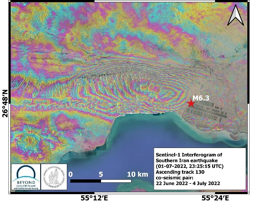
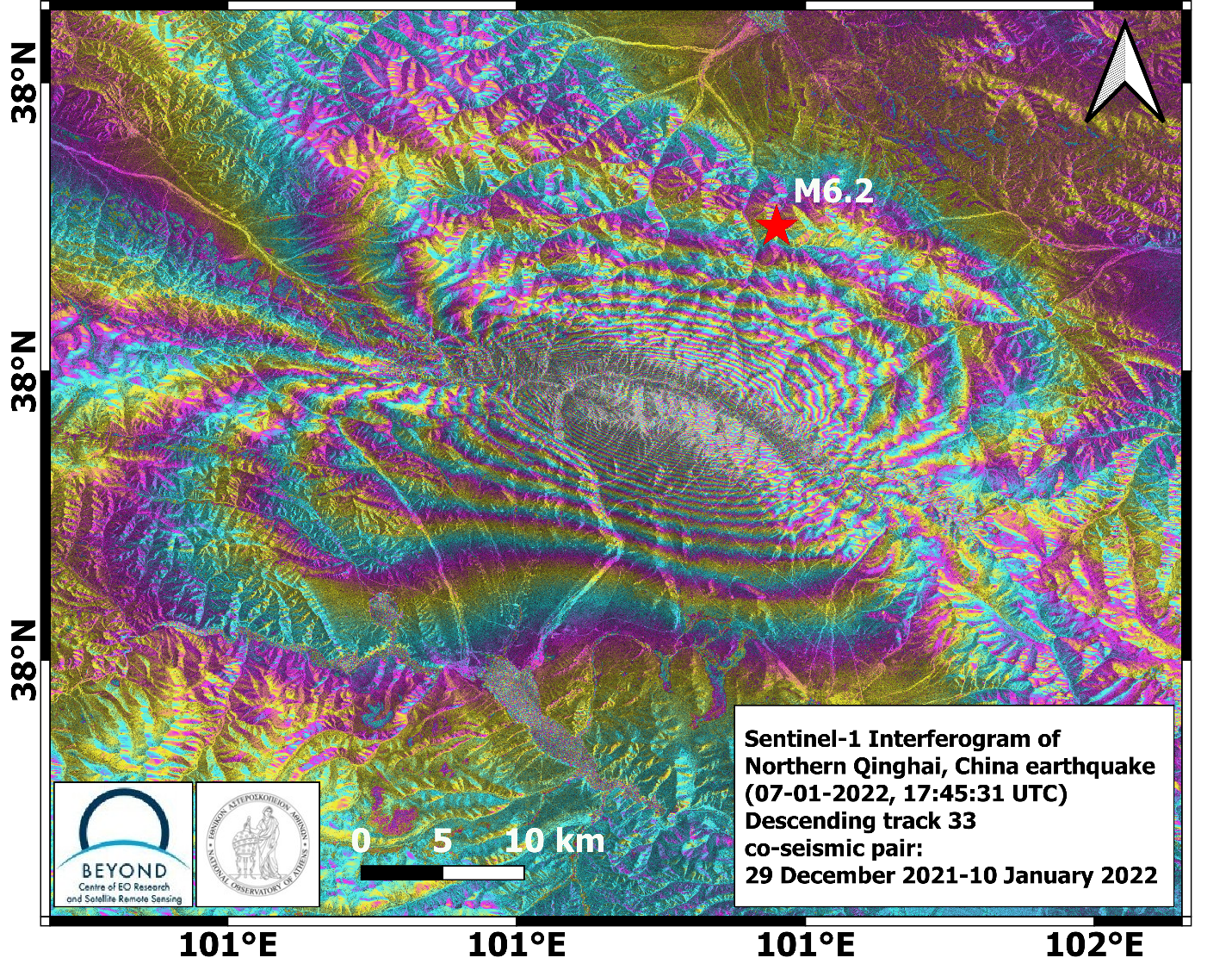
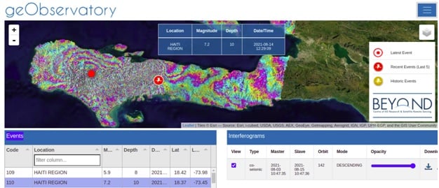
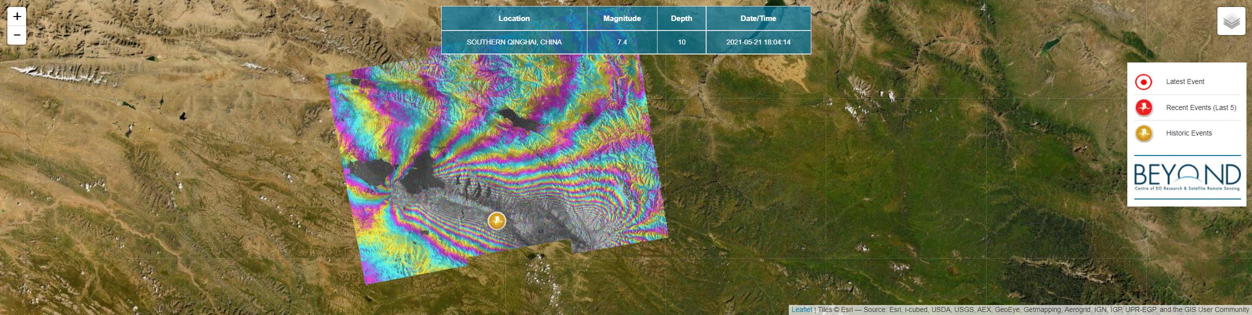
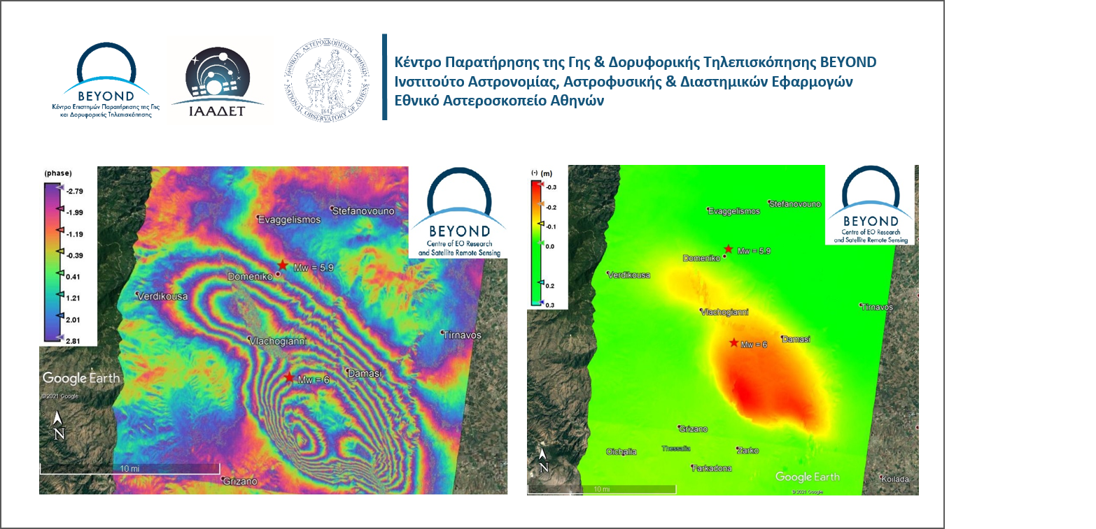
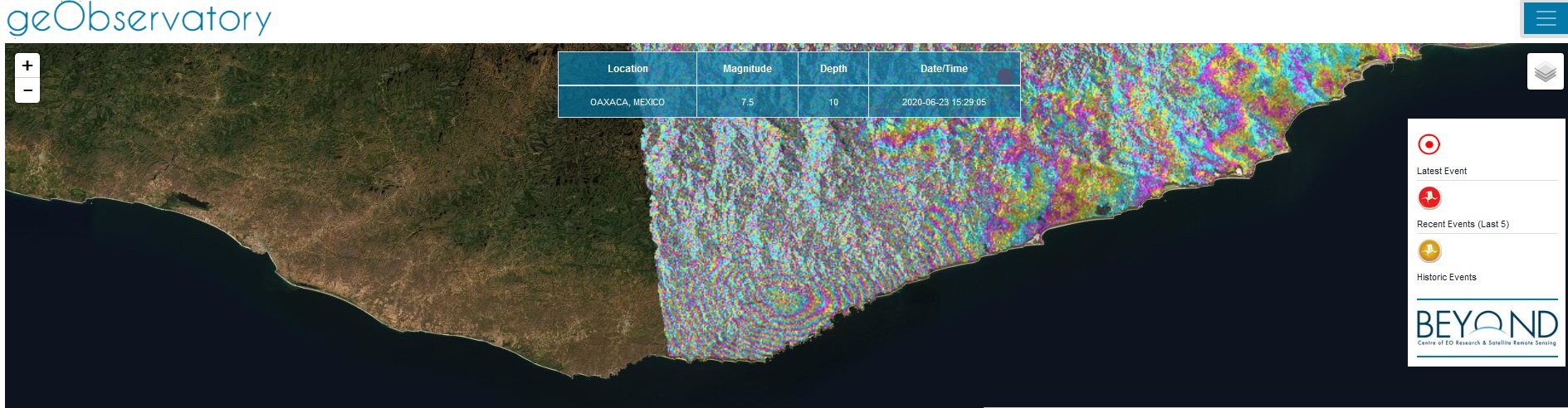
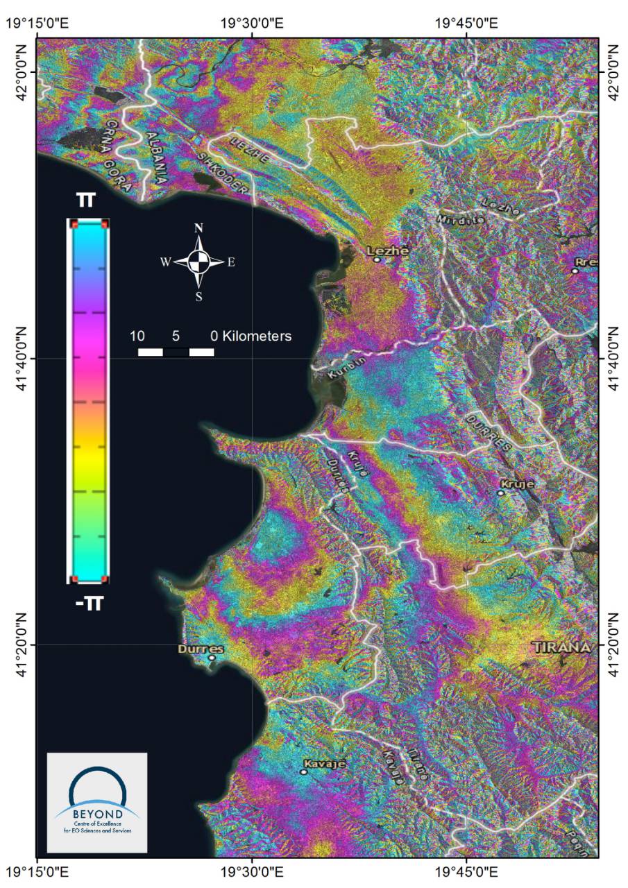
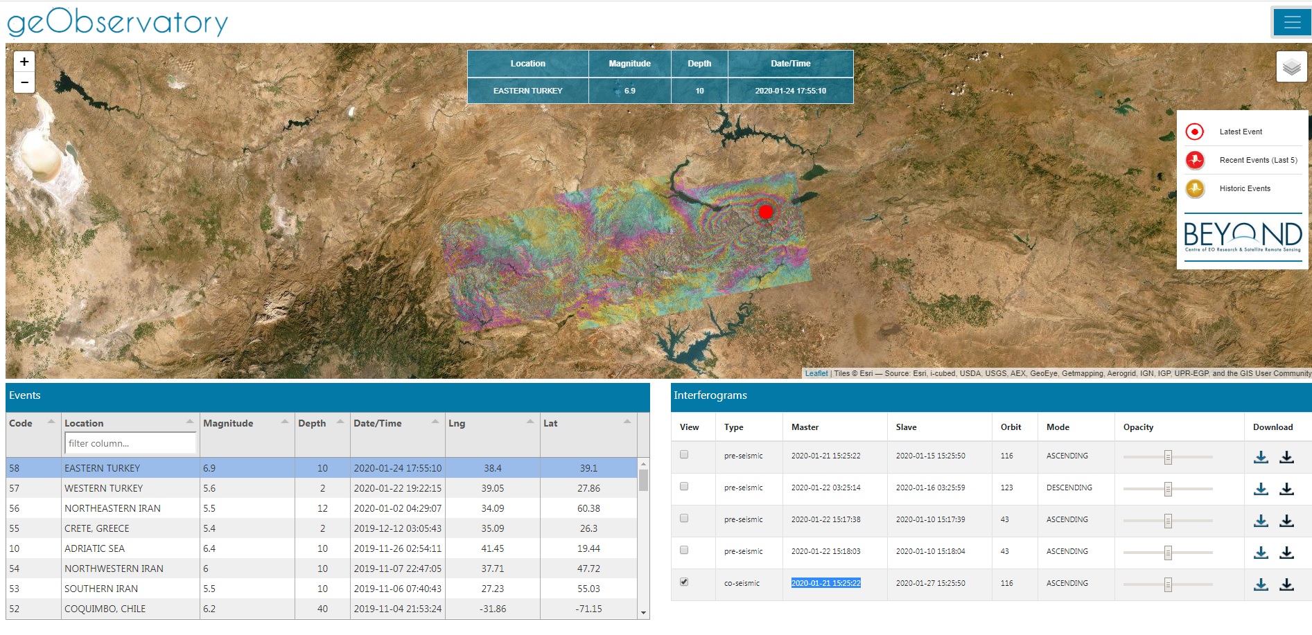
Το Κέντρο Αριστείας BEYOND μέσω της υπηρεσίας του geObservatory παράγει αυτόματα όλα τα αναγκαία συμβολογραφήμματα (interferograms)  πριν και μετά τον σεισμό και δίνει τη δυνατότητα λήψης των εικόνων (interferograms) για περαιτέρω ανάλυση στην επιστημονική κοινότητα. 

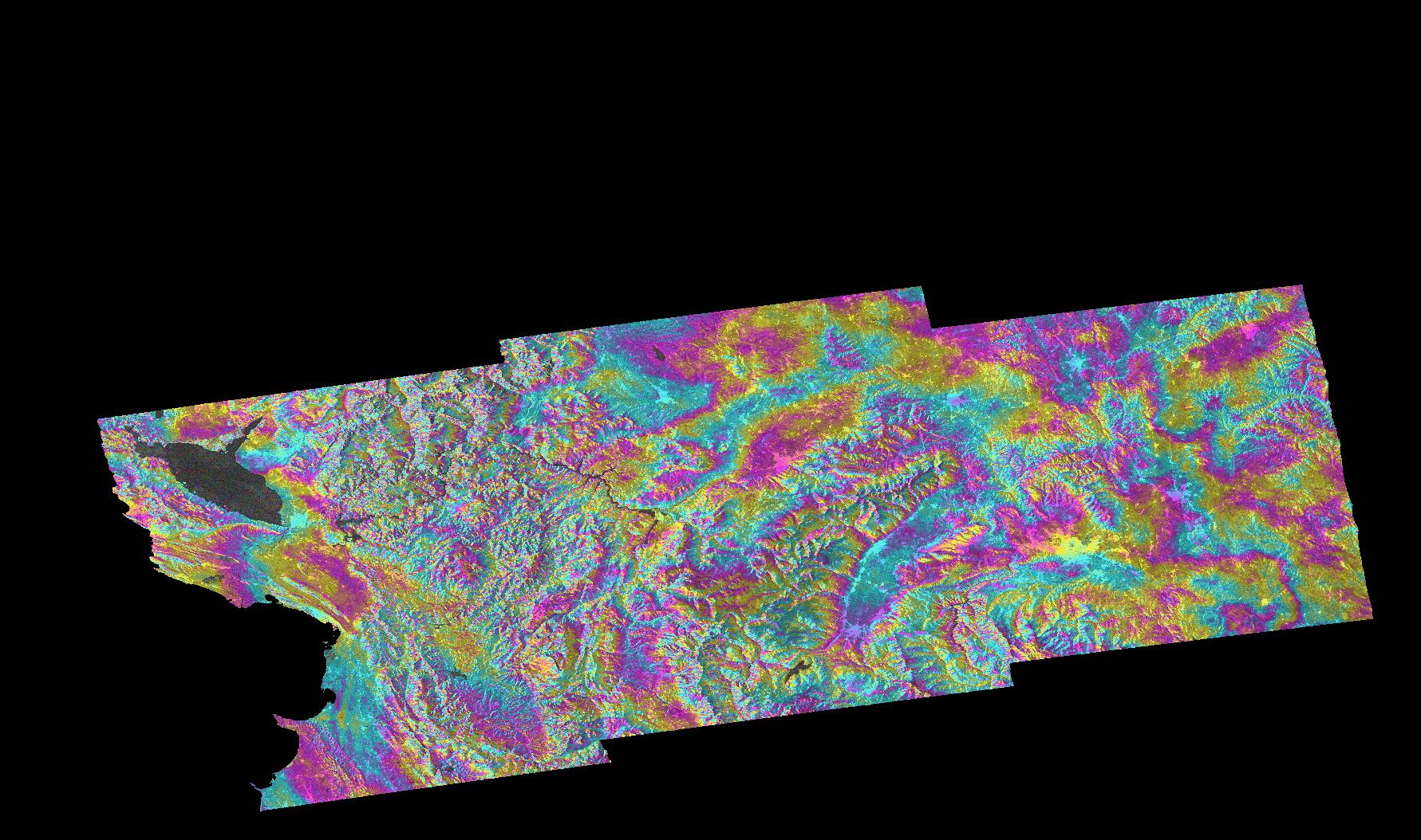
Την Παρασκευή 24.01.2020 στις 20:55 (τοπική ώρα) σημειώθηκε σεισμική δόνηση μεγέθους 6,9 βαθμών Ρίχτερ με 10 μέτρα εστιακό βάθος στην Ανατολική Τουρκία και συγκεκριμένα στην περιοχή Ελαζίγ. Μέχρι στιγμή ο τραγικός απολογισμός είναι 41 νεκροί.

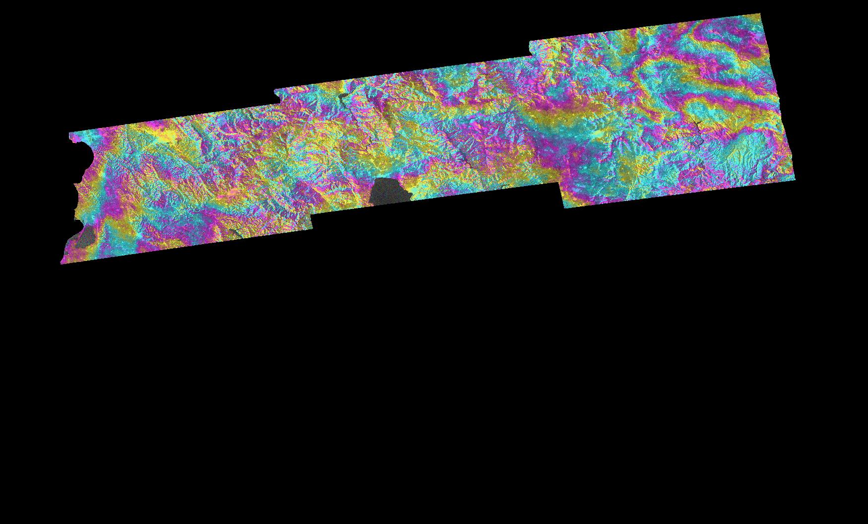
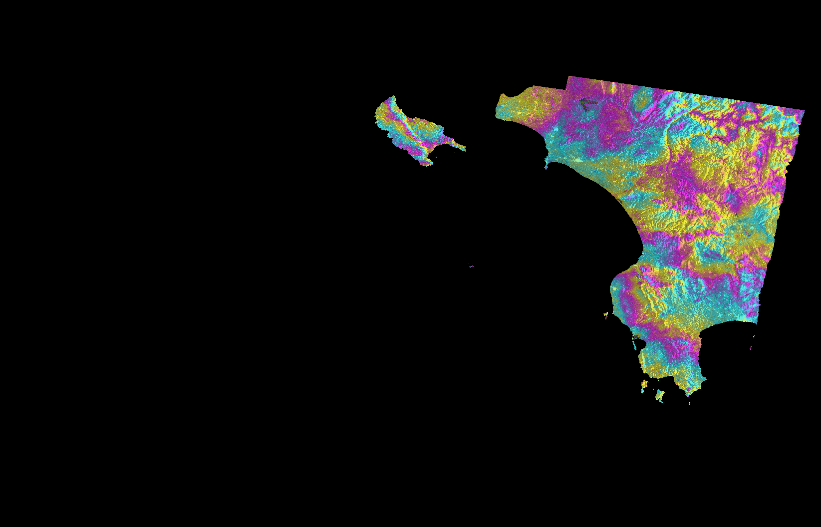
Συγκεκριμένα για τον πρόσφατο καταστροφικό σεισμό στην ανατολική Τουρκία έγινε εκτίμηση της εδαφικής παραμόρφωσης στην περιοχή, μέσα από την επεξεργασία δορυφορικών εικόνων Sentinel-1 που συλλέχθησαν στα Copernicus Hubs που λειτουργεί το BEYOND/EAA.

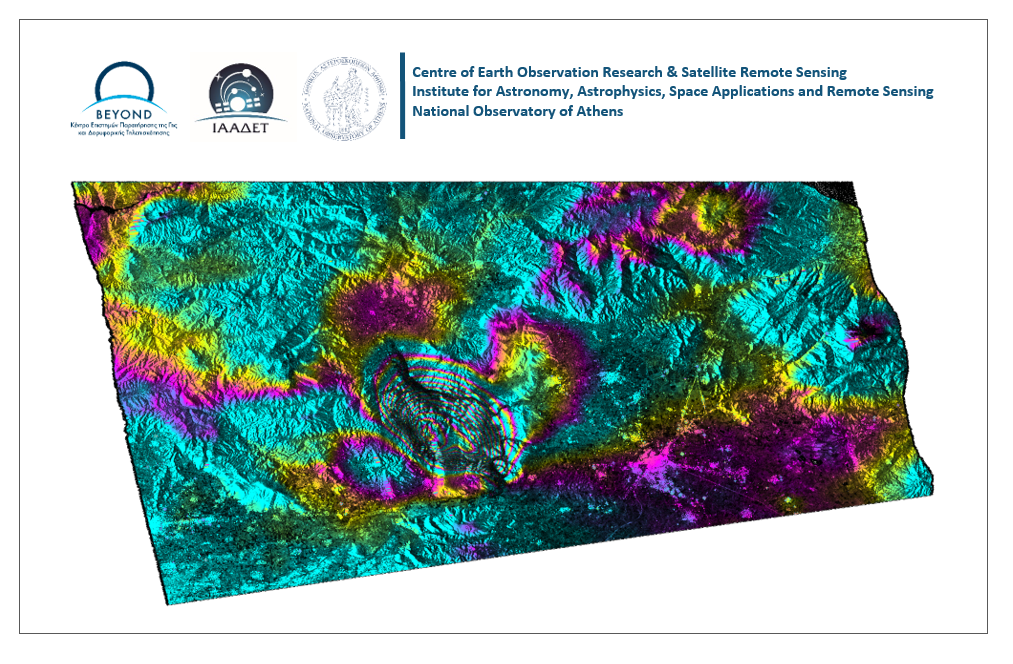
Η ανάλυση του σεισμού (co-seismic interferogram) έγινε με εικόνες πριν και μετά τον σεισμό (Master 2020-01-21 15:25:22, Slave 2020-01-27 15:25:50) και παρατηρούμε ένα μοτίβο κροσσών συμβολής που αντιστοιχούν σε μετατόπιση του εδάφους. Ο αριθμός των κροσσών ίδιου χρώματος δείχνει το μέγεθος της μετατόπισης (2,8 cm ανά κροσσό). Στο αντίστοιχο pre-seismic interferogram ( Master 2020-01-21 15:25:22, Slave 2020-01-15 15:25:50 ) που έχει δημιουργηθεί με εικόνες πριν τον σεισμό δεν παρατηρούνται κροσσοί.

Η υπηρεσία geObservatory είναι ανοιχτή και ελεύθερη για χρήση από όλη την επιστημονική κοινότητα η οποία μπορεί να  χρησιμοποιήσει όλα τα παραγόμενα συμβολγραφήμματα για πιο εξειδικευμένες αναλύσεις. Οι χρήστες καλούνται να επισκεφτούν την υπηρεσία geObservatory http://geobservatory.beyond-eocenter.eu/ και να χρησιμοποιήσουν την online γεωχωρική εφαρμογή για να δουν και να κατεβάσουν τα διαφορικά συμβολογραφήμματα, τόσο για τον σεισμό της Ανατολικής Τουρκίας, όσο και για άλλα σημαντικά σεισμικά γεγονότα παγκόσμια.

preseismic

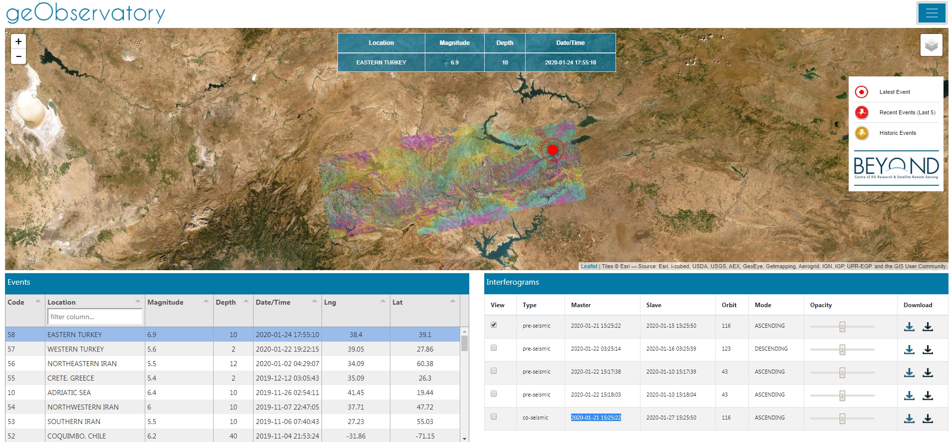
H περιοχή ενδιαφέροντος πριν το σεισμό 15/01/2020.

Το Κέντρο Αριστείας Επιστημών Παρατήρησης της Γης & Δορυφορικής Τηλεπισκόπησης "BEYOND" του Ινστιτούτου Αστρονομίας Αστροφυσικής Διαστημικών Εφαρμογών και Τηλεπισκόπησης του Εθνικού Αστεροσκοπείου Αθηνών συμμετέχει στην  4η Διεθνή Έκθεση “Verde.tec – Τεχνολογίες Περιβάλλοντος”, από 20 - 22 Μαρτίου, στο M.E.C. Παιανίας.

Θα χαρούμε να σας συναντήσουμε στο περίπτερο μας, για να γνωρίσετε από κοντά τόσο τις υπηρεσίες μας όσο και τους ανθρώπους πίσω από αυτές, αλλά και στην Ημερίδα μας που θα διοργανωθεί στο πλαίσιο της έκθεσης, στο Verde.tecForum.

 Viber 2019 11 27 17 10 08


Pre-seismic and co-seismic interferograms for the latest Mw6.5 #Durres earthquake in Albania are available to view and download: https://bit.ly/2Legbsb
Fully automatic solution from BEYOND geObservatory.
Each color fringe represents 2.8cm of surface displacement in the satellite line-of-sight.
http://geobservatory.beyond-eocenter.eu/

albania


No deformation fringes for the Magnitude 5.6, 2019-09-21 shallow Albania EQ.
6-day Sentinel-1A&B repeat pass cycle is impressive though for rapid deformation assessment.
Co-seismic and pre-seismic interferograms available at BEYOND geObservatory: http://tiny.cc/hal6cz

albania1

zakynthos lowResolution

Το Κέντρο Αριστείας BEYOND του ΕΑΑ παρήγαγε ένα πρώτο διαφορικό συμβολόγραμμα που αφορά τον σημερινό σεισμό στη Ζάκυνθο και στο οποίο δεν ανιχνεύεται κάποια εδαφική παραμόρφωση.

Για την ανάλυση χρησιμοποιήθηκαν δεδομένα Sentinel-1 και η επεξεργασία των εικόνων ξεκίνησε αυτόματα με τη λήψη της πρώτης διαθέσιμης εικόνας μετά τον σεισμό.

Η υπηρεσία geObservatory είναι διαθέσιμη στη σελίδα :

http://beyond-eocenter.eu/geohub/ του Κέντρου Αριστείας BEYOND και παράγει αυτοματοποιημένα προϊόντα συμβολομετρίας μετά από σημαντικά σεισμικά γεγονότα και ηφαιστειακές εξάρσεις οπουδήποτε στον κόσμο.

Οι χρήστες μπορούν να προβάλλουν και να κατεβάζουν ελεύθερα τα προϊόντα που βρίσκονται στην εφαρμογή geObservatory.


Α quicklook of the differential interferogram produced for today’s earthquake in Zakynthos island, Greece. This is a raw interferogram, and no manual operations for fine-tuning the processing parameters have been applied.
No fringe pattern is evident in the island.

Sentinel-1 data were used and a fully automatic processing engine was activated a few minutes after the earthquake occurrence. This engine is named geObservatory and a beta-version front-end is available here:

http://beyond-eocenter.eu/geohub/

Note that this is work in progress and any feedback on the functionality of geObservatory is welcome!

The event’s specific page is available here:


http://beyond-eocenter.eu/geohub/ionian-sea-2018-10-25-225451/

More interferograms will automatically populate this page as new Sentinel-1 data arrive.

Users can freely visualize and download the raw interferograms that are output from the geObservatory application of BEYOND Center Of Excellence.


After a week of intense micro-seismic activity in the wider area of the Kīlauea volcano in Hawaii, suddenly last Thursday a volcanic crack appeared near the road network, from which lava and hot steam appeared. The Civil Protection instructed residents of the Puna community (~ 10,000) to leave their homes immediately. On Friday, May 4, 2018, a powerful 6.9 earthquake hit the Big Island, the largest in the past 43 years.

The 2018 Oaxaca earthquake occurred on February 16, 2018 at 17:39 local time (23:39 UTC) in the Sierra Madre del Sur in Oaxaca state in Southern Mexico. It had a magnitude of 7.2 on the moment magnitude scale and a maximum felt intensity of VII (very strong) on the Mercalli intensity scale. The hypocenter was located at a depth of 24.6 km and approximately 37 km northeast of Pinotepa de Don Luis.

On 12/11/2017, late Sunday, an earthquake of magnitude 7.3 struck near the border of Iran and Iraq. At least 452 people were killed and thousands injured, while the earthquake was felt as far away as Turkey and Pakistan. Around 100 of the dead are believed to be from one town in Iran's Kermanshah province. Mapping of the surface deformation with Sentinel-1 data, available through the Greek Mirror Site (https://sentinels.space.noa.gr/).